Bay of Fires
|
 |
- Tasmania -
| |
|||
Information about Tasmania: Tasmania is an island state of Australia which is located 240 km (150 mi) to the south of the Australian mainland. Only separated by Bass Strait. The state encompasses the main island of Tasmania. It is also the 26th-largest island in the world. The state has a population of about 540,000 people as of March 2020 . The capital and the largest city is Hobart, which has around 40 percent of the population living in the Greater Hobart area. Read More...
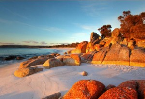
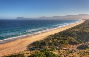
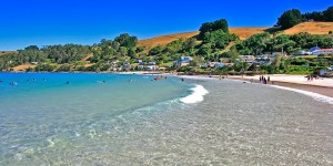
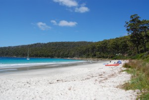
The Bay of Fires is a bay on the northeastern coast of Tasmania in Australia, extending from Binalong Bay to Eddystone Point. The bay was given its name in 1773 by Captain Tobias Furneaux in Adventure, who saw the fires of Aboriginal people on the beaches. The Bay of Fires is a region of white beaches, blue water and orange-hued granite (the colour of which is actually produced by a lichen). The northern section of the bay is part of Mount William National Park; the southern end is a conservation area. Behind the beaches are several lagoons and inlets brimming with bird life, which are protected in the Bay of Fires Conservation area. A wide range of activities can be pursued in the Bay of Fires area, including camping, beach activities, boating, bird watching, fishing, swimming, surfing and walking. It is a popular spot for swimming as it is one of the island’s more sheltered beaches. The bustling little township of Adventure Bay is an island hub. Named after Captain Tobias Furneax’ ship the Adventure (1773), Adventure Bay is the first sheltered anchorage for ships traversing the Southern Ocean. It was a major safe anchorage for a host of early explorers including captains Cook, Bligh, d’Entrecasteaux, Tobin and Furneaux. At The Neck you can climb the long staircase to the top of the dunes for a 360-degree panoramic view of the isthmus. This is also where you can see fairy penguins and mutton birds returning to their nests at dusk. In the south there are terrific bushwalks around Fluted Cape. Located on Tasmania’s north west coast, just 15 minutes from the Burnie/Wynyard Airport, Boat Harbour Beach is a locals’ secret. It is a gorgeous crescent-shaped beach tucked beneath the hillside of a pretty little holiday village. Lifesavers from the Boat Harbour Surf Life Saving Club (which also run the waterfront café Harvest and Cater) patrol through the summer months and the crystal clear water is perfect for swimming and diving. A walkway winds along Port Road from the beach to the top of the escarpment giving spectacular views of the pristine sands with vistas of Table Cape to the east and Rocky Cape to the west. It’s a perfect Tasmania beach for a summer holiday. Completely surrounded by the Tasman National Park on the Tasman Peninsula, Fortescue Bay is a secluded wilderness beach of sugar-white sand that is generally quite safe because it is protected by headlands of high dolerite cliffs. The magnificent cliffs near Fortescue Bay would be enough to win it the prize of being one of the best beaches in Tasmania. It is also a popular boating destination because of the sheltered waters and good fishing and there is a boat launching ramp. There are excellent day walks to places like Canoe Bay with its shipwreck offshore and through heath and woodland to get fabulous views of the steep cliffs and unusual rock formations at Cape Hauy.Tasmania Beaches
Bay of Fires
Adventure Bay Beach
Adventure Bay is a long scallop of Eastern-facing sandy beach that stretches from Fluted Cape in the south to the isthmus called The Neck that connects South Bruny and North Bruny islands.Boat Harbour Beach
Fortescue Bay
 |
 |
 |
 |
 |
 |
 |
 |
 |
 |
 |
Copyright © 2014 World Infos. All Rights Reserved. This site is developed by World-infos Terms & Conditions/Disclaimer - Privacy & Legal Advertisement: advertise@world-infos.com Contact: information@world-infos.com |
|
|||